| grids {geofacet} | R Documentation |
Geo Grids
Description
There are now 141 grids available in this package and more online. To view a full list of available grids, see here. To create and submit your own grid, see here. To see several examples of grids being used to visualize data, see facet_geo.
-
us_state_grid1: Grid layout for US states (including DC) Image reference here.
-
us_state_grid2: Grid layout for US states (including DC) Image reference here.
-
eu_grid1: Grid layout for the 28 EU Countries Image reference here.
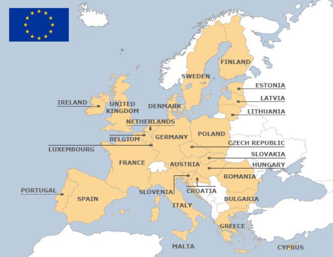
-
aus_grid1: Grid layout for the Australian States and Territories. Image reference here. Thanks to jonocarroll.
-
sa_prov_grid1: Grid layout for the provinces of South Africa Image reference here. Thanks to jonmcalder.
-
gb_london_boroughs_grid: Grid layout for the boroughs of London. Note that the column
code_onscontains the codes used by UK Office for National Statistics. Image reference here. Thanks to eldenvo.
-
nhs_scot_grid: Grid layout for a grid of NHS Scotland Health Boards. Note that the column
codecontains the codes used by UK Office for National Statistics. Image reference here. Thanks to jsphdms.
-
india_grid1: Grid layout for India states (not including union territories). Image reference here. Thanks to meysubb.
-
india_grid2: Grid layout for India states (not including union territories). Image reference here.
-
argentina_grid1: Grid for the 23 provinces of Argentina. It includes the Malvinas/Falkland Islands and the Antarctic Territories (these are disputed, but they are included since many researchers might use data from these locations). Image reference here. Thanks to eliocamp.
-
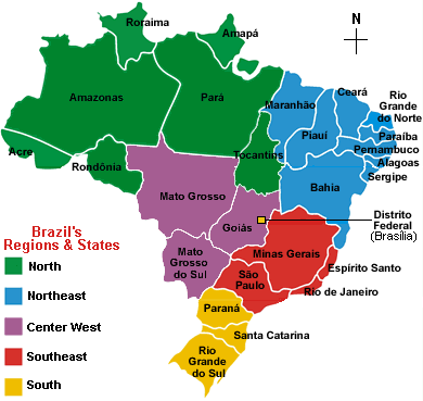
br_states_grid1: Grid for the 27 states of Brazil. Image reference here. Thanks to italocegatta.
-
fr_regions_grid1: Land and overseas regions of France. Codes are INSEE codes. Image reference here. Thanks to mtmx.
-
de_states_grid1: Grid for the German states ('Länder') Image reference here. Thanks to DominikVogel.
-
us_wa_counties_grid1: Grid for Washington counties. Image reference here.
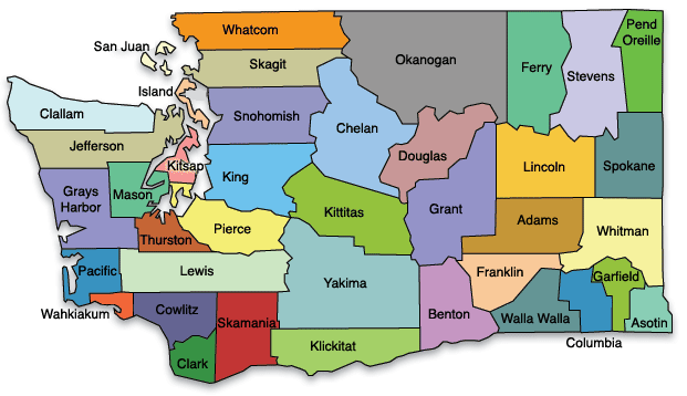
-
us_in_counties_grid1: Grid for Indiana counties. Image reference here. Thanks to nateapathy.
-
us_in_central_counties_grid1: Grid for central Indiana counties. Image reference here. Thanks to nateapathy.
-
sf_bay_area_counties_grid1: Grid of the 9 San Francisco Bay Area counties. Image reference here. Thanks to Eunoia.
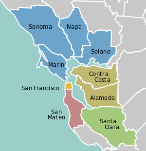
-
ua_region_grid1: Grid of administrative divisions of Ukraine (24 oblasts, one autonomous region, and two cities). Image reference here. Thanks to woldemarg.
-
mx_state_grid1: Grid layout for the states of Mexico. Image reference here. Thanks to ikashnitsky.
-
mx_state_grid2: Grid layout for the states of Mexico. Image reference here. Thanks to diegovalle.
-
scotland_local_authority_grid1: Grid layout for the local authorities of Scotland. Image reference here. Thanks to davidhen.
-
us_state_without_DC_grid1: Grid layout for US states (excluding DC) Image reference here. Thanks to ejr248.
-
italy_grid1: Grid layout for regions of Italy (in collaboration with Stella Cangelosi and Luciana Dalla Valle). Image reference here. Thanks to JulianStander.
-
italy_grid2: Grid layout for regions of Italy (in collaboration with Stella Cangelosi and Luciana Dalla Valle). Image reference here. Thanks to JulianStander.
-
be_province_grid1: Grid layout for provinces of Belgium plus Brussels, including names in three languages (French, Dutch, English) and Belgium internal codes (NIS). Image reference here. Thanks to ericlecoutre.
-
us_state_grid3: Grid layout for US states (including DC). Image reference here. Thanks to kanishkamisra.
-
ng_state_grid1: Grid layout for the 37 Federal States of Nigeria. Image reference here. Thanks to aledemogr.
-
bd_upazila_grid1: Grid layout for Bangladesh 64 Upazilas. Image reference here. Thanks to aledemogr.
-
ch_cantons_grid1: Grid layout for Cantons of Switzerland. Image reference here. Thanks to tinu-schneider.
-
world_86countries_grid: Grid layout for 86 countries in the world. Image reference here. Thanks to akangsha.
-
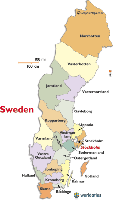
se_counties_grid2: Grid for counties of Sweden. Image reference here. Thanks to richardohrvall.
-
uk_regions1: Grid for regions of the UK (aka EU standard NUTS 1 areas). Image reference here. Thanks to paulb20.
-
us_state_contiguous_grid1: Grid layout for the contiguous US states (including DC). Image reference here. Thanks to andrewsr.
-
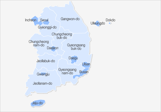
sk_province_grid1: Grid layout for South Korean sis and dos (metropolitan/special/autonomous cities and provinces). Image reference here. Thanks to heon131.
-
ch_aargau_districts_grid1: Grid layout for Districts of the Canton of Aargau, Switzerland. Image reference here. Thanks to zumbov2.
-
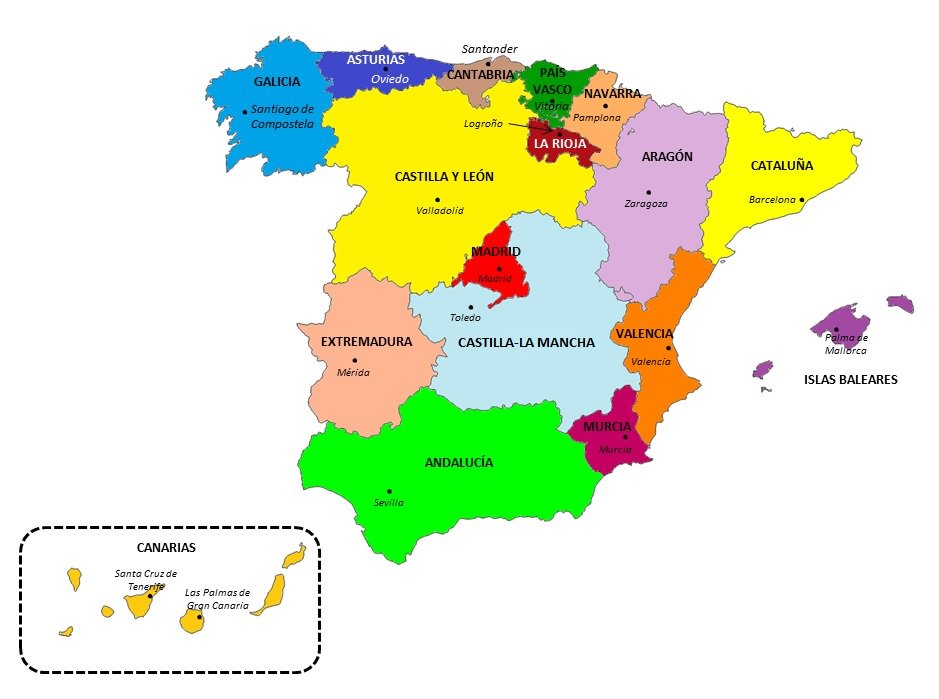
spain_ccaa_grid1: Grid layout for Spanish 'Comunidades Autónomas'. Image reference here. Thanks to JoseAntonioOrtega.
-
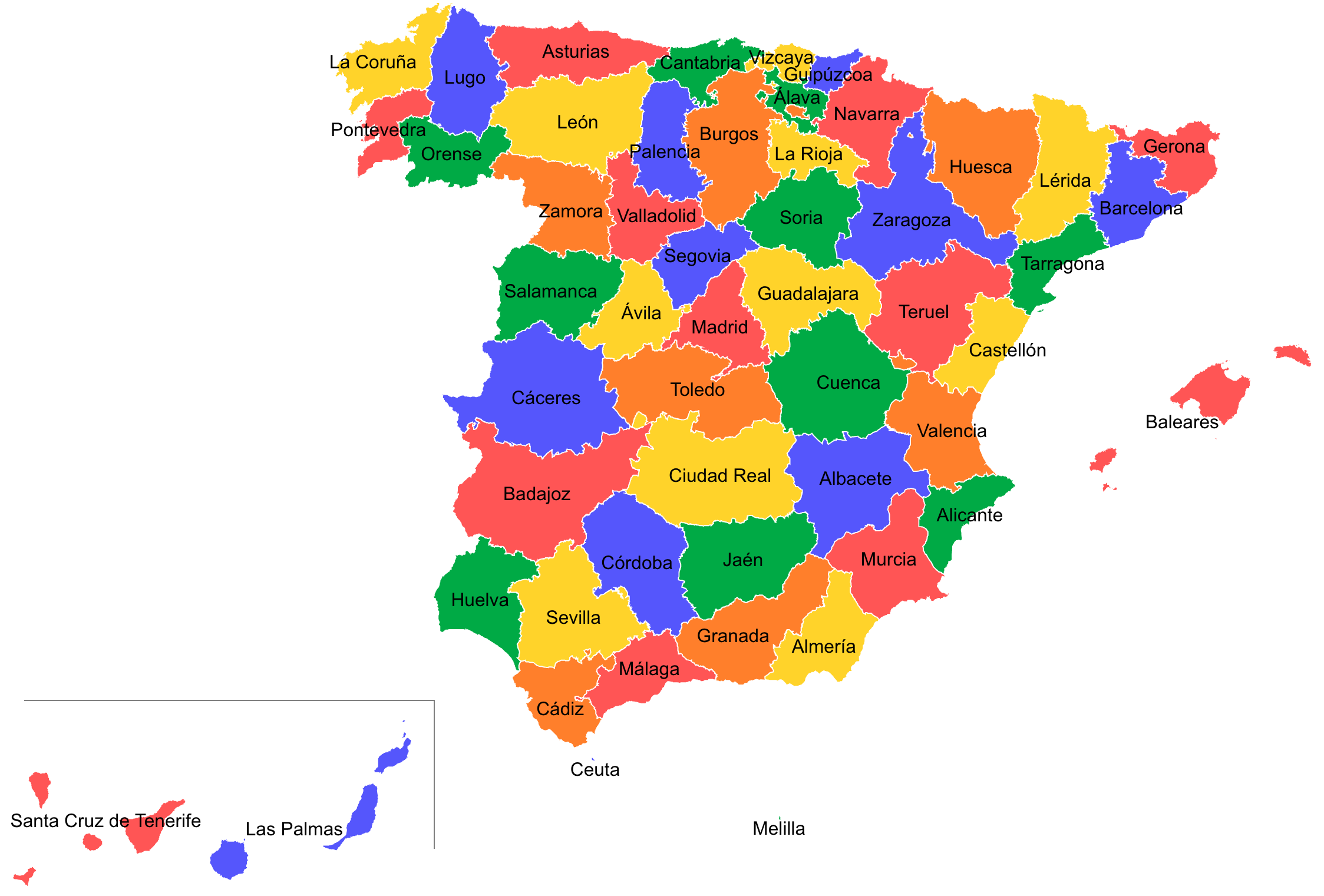
spain_prov_grid2: Grid layout for Provinces of Spain. Image reference here. Thanks to JoseAntonioOrtega.
-
world_countries_grid1: Grid layout for countries of the world, with a few exclusions. See . Image reference here. Thanks to JoseAntonioOrtega.
-
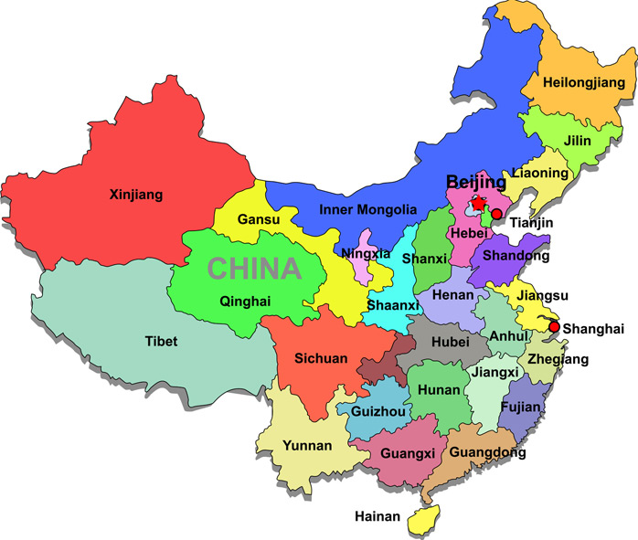
china_city_grid1: Grid layout of cities in China. Image reference here. Thanks to CharleneDeng1.
-
kr_seoul_district_grid1: Grid layout of Seoul's 25 districts. Image reference here. Thanks to yonghah.
-
nz_regions_grid1: Grid layout for regions of New Zealand. Image reference here. Thanks to pierreroudier.
-
ar_tucuman_province_grid1: Grid layout for Argentina Tucumán Province political divisions (departments) Image reference here. Thanks to TuQmano.
-
us_nh_counties_grid1: Grid layout for the 10 counties in New Hampshire. Image reference here. Thanks to ghost.
-
pl_voivodeships_grid1: Grid layout for Polish voivodeships (provinces) Image reference here. Thanks to erzk.
-
ar_cordoba_dep_grid1: Grid layout for departments of Cordoba province in Argentina. Image reference here. Thanks to TuQmano.
-
ar_buenosaires_communes_grid1: Grid for communes of Buenos Aires, Argentina. Image reference here. Thanks to TuQmano.
-
nz_regions_grid2: Grid layout for regions of New Zealand. Image reference here. Thanks to pierreroudier.
-
ec_prov_grid1: Grid layout for provinces of Ecuador Image reference here. Thanks to Ricardo95RM.
-
nl_prov_grid1: Grid layout for provinces of Netherlands Image reference here. Thanks to ruditurksema.
-
ca_prov_grid1: Grid layout for provinces of Canada Image reference here. Thanks to michael-chong.
-
us_nc_counties_grid1: Grid layout for Counties of North Carolina, United States Image reference here. Thanks to mtdukes.
-
mx_ciudad_prov_grid1: Grid layout for Districts of Mexico City, Mexico Image reference here. Thanks to Ivangea.
-
bg_prov_grid1: Grid layout for provinces of Bulgaria Image reference here. Thanks to savinastoitsova.
-
us_hhs_regions_grid1: This grid approximates the U.S. Health and Human Services Region map Image reference here. Thanks to akitepowell.
-
tw_counties_grid1: Grid layout for Counties of Taiwan Image reference here. Thanks to csh484912274.
-
tw_counties_grid2: Grid layout for Counties of Taiwan including Lienchiang County Image reference here. Thanks to csh484912274.
-
us_mi_counties_grid1: Grid layout for Counties of Michigan, United States Image reference here. Thanks to jrennyb.
-
pe_prov_grid1: Grid layout for Provinces of Peru Image reference here. Thanks to jmcastagnetto.
-
sa_prov_grid2: Grid layout for Provinces of South Africa Image reference here. Thanks to kamermanpr.
-
mx_state_grid3: Grid layout for States of Mexico Image reference here. Thanks to ikashnitsky.
-
cn_bj_districts_grid1: Grids for Administrative Districts of Beijing, China Image reference here. Thanks to shiedelweiss.
-
us_va_counties_grid1: Grids for Counties of Virginia, United States Image reference here. Thanks to joshyazman.
-
us_mo_counties_grid1: Grids for Counties of Missouri, United States Image reference here. Thanks to Yanqi-Xu.
-
cl_santiago_prov_grid1: Communes of Santiago Province, Chile Image reference here. Thanks to robsalasco.
-
us_tx_capcog_counties_grid1: This is a grid of a 10 county planning region around Austin, Texas, United States Image reference here. Thanks to mth444.
-
sg_planning_area_grid1: Grids for Planning Areas of Singapore Image reference here. Thanks to Elenafuyi.
-
in_state_ut_grid1: Grid of Indian States and Union Territories Image reference here. Thanks to seanangio.
-
cn_fujian_prov_grid1: Grid of counties of Fujian Province, China Image reference here. Thanks to nannanchen333.
-
ca_quebec_electoral_districts_grid1: Grid of Electoral Districts of Québec, Canada Image reference here. Thanks to jhroy.
-
nl_prov_grid2: Grid with the provinces of The Netherlands with codes that are used by the statistical institute of NL Image reference here. Thanks to edwindj.
-
cn_bj_districts_grid2: Grid with districts of Beijing, China Image reference here. Thanks to zouhx11.
-
ar_santiago_del_estero_prov_grid1: Grid with districts of Santiago del Estero Province, Argentina Image reference here. Thanks to TuQmano.
-
ar_formosa_prov_grid1: Grid with districts of Formosa Province, Argentina Image reference here. Thanks to TuQmano.
-
ar_chaco_prov_grid1: Grid with districts of Chaco Province, Argentina Image reference here. Thanks to TuQmano.
-
ar_catamarca_prov_grid1: Grid with districts of Catamarca Province, Argentina Image reference here. Thanks to TuQmano.
-
ar_jujuy_prov_grid1: Grid with districts of Jujuy Province, Argentina Image reference here. Thanks to TuQmano.
-
ar_neuquen_prov_grid1: Grid with districts of Neuquen Province, Argentina Image reference here. Thanks to TuQmano.
-
ar_san_luis_prov_grid1: Grid with districts of San Luis Province, Argentina Image reference here. Thanks to TuQmano.
-
ar_san_juan_prov_grid1: Grid with districts of San Juan Province, Argentina Image reference here. Thanks to TuQmano.
-
ar_santa_fe_prov_grid1: Grid with districts of Santa Fe Province, Argentina Image reference here. Thanks to TuQmano.
-
ar_la_rioja_prov_grid1: Grid with districts of La Rioja Province, Argentina Image reference here. Thanks to TuQmano.
-
ar_mendoza_prov_grid1: Grid with districts of Mendoza Province, Argentina Image reference here. Thanks to TuQmano.
-
ar_salta_prov_grid1: Grid with districts of Salta Province, Argentina Image reference here. Thanks to TuQmano.
-
ar_rio_negro_prov_grid1: Grid with districts of Rio Negro Province, Argentina Image reference here. Thanks to TuQmano.
-
ar_buenos_aires_prov_electoral_dist_grid1: Grid with Electoral Districts of Buenos Aires Province, Argentina Image reference here. Thanks to TuQmano.
-
europe_countries_grid1: Grid layout for all European countries except Vatican City, Monaco, San Marino and Liechtenstein Image reference here. Thanks to THargreaves.
-
argentina_grid2: Grid layout for Argentina without Islas Malvinas and Antártida Argentina Image reference here. Thanks to TuQmano.
-
us_state_without_DC_grid2: Grid layout for United States with AK and HI flush with CA Image reference here. Thanks to christophercannon.
-
mm_state_grid1: States of Myanmar Image reference here. Thanks to htinkyawaye.
-
us_state_with_DC_PR_grid1: United States of America including Washington, D.C. and Puerto Rico Image reference here. Thanks to krothkin.
-
fr_departements_grid1: Grid for France's departements, the second levels of administrative boundaries after the regions Image reference here. Thanks to tvroylandt.
-
ar_salta_prov_grid2: Grids for Salta Province Argentina Image reference here. Thanks to tartagalensis.
-
ie_counties_grid1: Ireland counties. Code is the car number plate abbreviation for Republic counties, similar for the six counties of Northern Ireland. Tipperary is split North / South for historical reasons Image reference here. Thanks to eugene100hickey.
-
us_ny_counties_grid1: Counties of New York State, United States Image reference here. Thanks to jjdfsny.
-
ru_federal_subjects_grid1: Federal Subjects of Russia Image reference here. Thanks to ParanoidAndroid18.
-
us_ca_counties_grid1: Counties of the State of California, United States Image reference here. Thanks to MartinLe5.
-
lk_districts_grid1: Second level administrative divisions of Sri Lanka Image reference here. Thanks to thiyangt.
-
us_state_without_DC_grid3: United States grid without Washington, D.C Image reference here. Thanks to ghost.
-
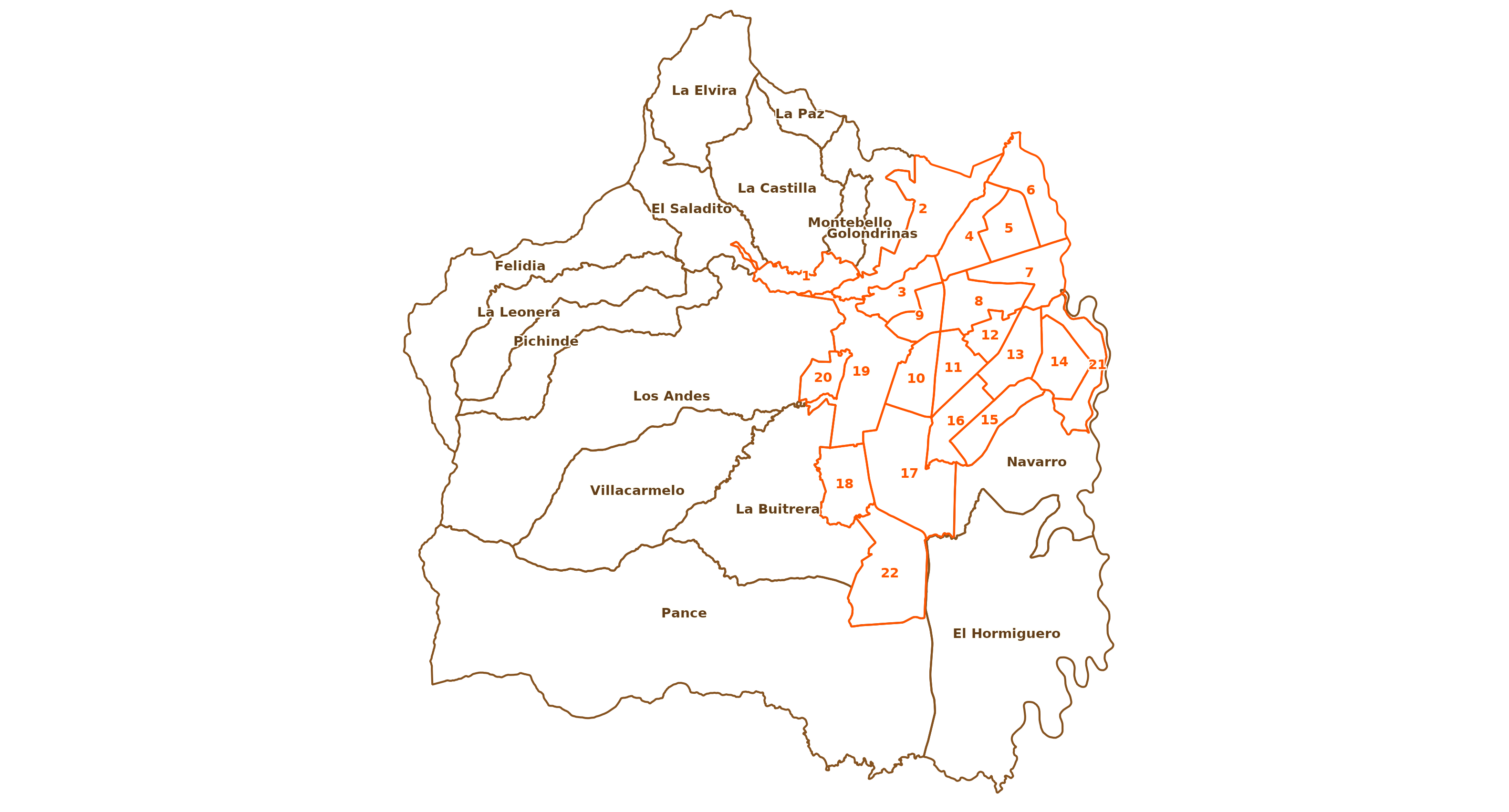
co_cali_subdivisions_grid1: Corregimientos of Cali, Columbia Image reference here. Thanks to Carolina101.
-
us_in_northern_counties_grid1: Northern Counties of Indiana, United States Image reference here. Thanks to robertoge.
-
italy_grid3: Autonomous Provinces of Italy Image reference here. Thanks to danilolofaro.
-
us_state_with_DC_PR_grid2: Grid of 50 states, DC, and Puerto Rico Image reference here. Thanks to krmaas.
-
sg_planning_area_grid2: Singapore Planning Areas Image reference here. Thanks to ZhimaoElliott.
-
ch_cantons_fl_grid1: Grid layout for Cantons of Switzerland and the neighbouring Prinicipality of Liechtenstein Image reference here. Thanks to rastrau.
-
europe_countries_grid2: Grid layout for European countries (minus micro nations) Image reference here. Thanks to rastrau.
-
us_states_territories_grid1: Grid layout for U.S. states and territories Image reference here. Thanks to rastrau.
-
us_tn_counties_grid1: Grid layout for counties of Tennesee, United States Image reference here. Thanks to binkleym.
-
us_il_chicago_community_areas_grid1: Grid layout for the Community Areas of Chicago Image reference here. Thanks to leungkp.
-
us_state_with_DC_PR_grid3: United States grid with Washington, D.C. and Puerto Rico Image reference here. Thanks to klittle314.
-
in_state_ut_grid2: Grid of Indian States and Union Territories Image reference here. Thanks to dnyansagar.
-
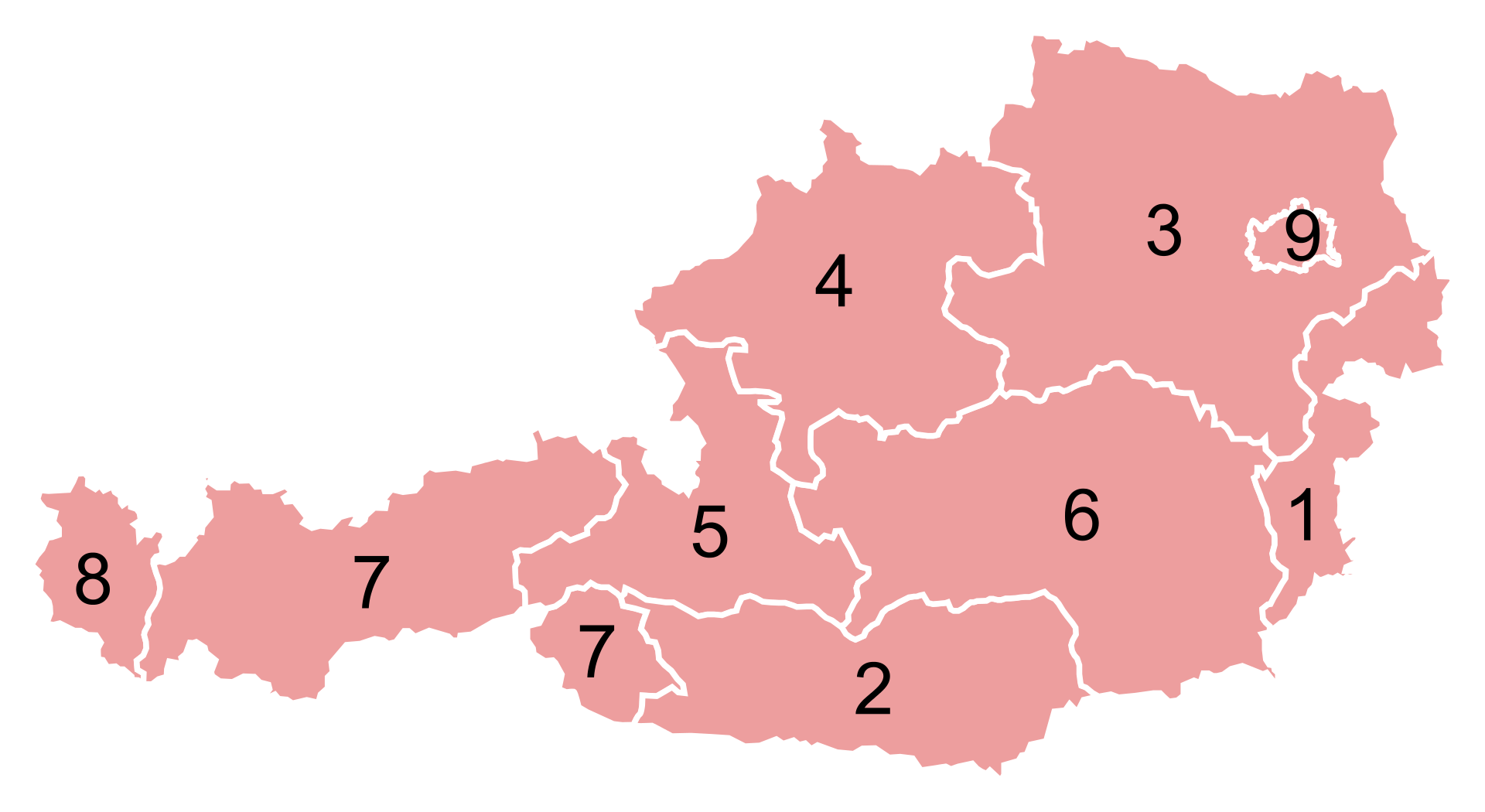
at_states_grid1: Grid layout for States of Austria Image reference here. Thanks to werkstattcodes.
-
us_pa_counties_grid1: Grid layout of Counties of Pennsylvania, United States Image reference here. Thanks to urbanSpatial.
-
us_oh_counties_grid1: Grid layout of Counties of Ohio, United States Image reference here. Thanks to taylorokonek.
-
fr_departements_grid2: Grid layout of Departements of France Image reference here. Thanks to jerbou.
-
us_wi_counties_grid1: Grid layout for counties of Wisconsin, United States Image reference here. Thanks to aravamu2.
-
africa_countries_grid1: Grid for all countries in Africa. Namibia added as 'NAM' to avoid NA collisions Image reference here. Thanks to ntncmch.
-
no_counties_grid1: Grid of counties of Norway Image reference here. Thanks to NanAmalie1.
-
tr_provinces_grid1: Grid of Provinces of Turkey Image reference here. Thanks to sadettindemirel.
Usage
us_state_grid1

us_state_grid2

eu_grid1

aus_grid1

sa_prov_grid1

gb_london_boroughs_grid

nhs_scot_grid

india_grid1

india_grid2

argentina_grid1

br_states_grid1

sea_grid1

mys_grid1

fr_regions_grid1

de_states_grid1

us_or_counties_grid1

us_wa_counties_grid1

us_in_counties_grid1

us_in_central_counties_grid1

se_counties_grid1

sf_bay_area_counties_grid1

ua_region_grid1

mx_state_grid1

mx_state_grid2

scotland_local_authority_grid1

us_state_without_DC_grid1

italy_grid1

italy_grid2

be_province_grid1

us_state_grid3

jp_prefs_grid1

ng_state_grid1

bd_upazila_grid1

spain_prov_grid1

ch_cantons_grid1

ch_cantons_grid2

china_prov_grid1

world_86countries_grid

se_counties_grid2

uk_regions1

us_state_contiguous_grid1

sk_province_grid1

ch_aargau_districts_grid1

jo_gov_grid1

spain_ccaa_grid1

spain_prov_grid2

world_countries_grid1

br_states_grid2

china_city_grid1

kr_seoul_district_grid1

nz_regions_grid1

sl_regions_grid1

us_census_div_grid1

ar_tucuman_province_grid1

us_nh_counties_grid1

china_prov_grid2

pl_voivodeships_grid1

us_ia_counties_grid1

us_id_counties_grid1

ar_cordoba_dep_grid1

us_fl_counties_grid1

ar_buenosaires_communes_grid1

nz_regions_grid2

oecd_grid1

ec_prov_grid1

nl_prov_grid1

ca_prov_grid1

us_nc_counties_grid1

mx_ciudad_prov_grid1

bg_prov_grid1

us_hhs_regions_grid1

tw_counties_grid1

tw_counties_grid2

af_prov_grid1

us_mi_counties_grid1

pe_prov_grid1

sa_prov_grid2

mx_state_grid3

cn_bj_districts_grid1

us_va_counties_grid1

us_mo_counties_grid1

cl_santiago_prov_grid1

us_tx_capcog_counties_grid1

sg_planning_area_grid1

in_state_ut_grid1

cn_fujian_prov_grid1

ca_quebec_electoral_districts_grid1

nl_prov_grid2

cn_bj_districts_grid2

ar_santiago_del_estero_prov_grid1

ar_formosa_prov_grid1

ar_chaco_prov_grid1

ar_catamarca_prov_grid1

ar_jujuy_prov_grid1

ar_neuquen_prov_grid1

ar_san_luis_prov_grid1

ar_san_juan_prov_grid1

ar_santa_fe_prov_grid1

ar_la_rioja_prov_grid1

ar_mendoza_prov_grid1

ar_salta_prov_grid1

ar_rio_negro_prov_grid1

uy_departamentos_grid1

ar_buenos_aires_prov_electoral_dist_grid1

europe_countries_grid1

argentina_grid2

us_state_without_DC_grid2

jp_prefs_grid2

na_regions_grid1

mm_state_grid1

us_state_with_DC_PR_grid1

fr_departements_grid1

ar_salta_prov_grid2

ie_counties_grid1

sg_regions_grid1

us_ny_counties_grid1

ru_federal_subjects_grid1

us_ca_counties_grid1

lk_districts_grid1

us_state_without_DC_grid3

co_cali_subdivisions_grid1

us_in_northern_counties_grid1

italy_grid3

us_state_with_DC_PR_grid2

us_state_grid7

sg_planning_area_grid2

ch_cantons_fl_grid1

europe_countries_grid2

us_states_territories_grid1

us_tn_counties_grid1

us_il_chicago_community_areas_grid1

us_state_with_DC_PR_grid3

in_state_ut_grid2

at_states_grid1

us_pa_counties_grid1

us_oh_counties_grid1

fr_departements_grid2

us_wi_counties_grid1

africa_countries_grid1

no_counties_grid1

tr_provinces_grid1