| lumped_daily {airGRdatasets} | R Documentation |
Metadata and daily time series of catchment-scale hydro-meteorological observations
Description
The meteorological forcing is derived from the SAFRAN reanalysis (8 km resolution grid) produced by Météo-France (Vidal et al., 2010).
The meteorological forcing is aggregated at the catchment scale and merged to streamflow data in the CAMELS-FR database from INRAE (Delaigue et al., 2022). To do that, boundaries, area and elevation are calculated using the SRTM DEM (Werner, 2001); the stations were snaped on a theorical river network by INRAE (100 m resolution grid).
The streamflows, codes and name of hydrometric station are provided by the SCHAPI (the French Central Hydrometeorological and Flood Forecasting Support Service) on the Hydroportail website (SCHAPI, 2022). Streamflows are converted into mm/d using the DEM-based area.
Usage
A273011002
A605102001
B222001001
E540031001
E645651001
H010002001
H120101001
F439000101
H622101001
J171171001
J421191001
K134181001
K265401001
K731261001
V123521001
X031001001
X045401001
Y643401001
Y862000101
Format
[list] of 3 elements:
Meta [list] metadata
-
Code[list] of 2 [character] codes of the hydrometric station (H3: code since 2022,H2: former code) -
Name[character] name of the hydrometric station (H3) -
Coor[list] of 2 [numeric] coordinates (XandY) of the catchment outlet [decimal degrees; epsg: 4326] -
Area[numeric] area of the catchment [km²]
TS [data.frame] catchment daily time series from 1999-01-01 to 2018-12-31
-
Date[POSIXct] dates (timezone = "UTC") -
Ptot[numeric] total precipitation (liquid + solid) [mm/d] -
Temp[numeric] mean air temperature [°C] -
Evap[numeric] total potential evapotranspiration computed with Oudin's Formula (Oudin et al., 2005) -
Qls[numeric] outlet streamflow [l/s] -
Qmmd[numeric] outlet streamflow [mm/d]
Hypso [numeric] hypsometric values (101 quantiles from 0 to 100 % of the elevation range of the catchment) [m]
Note
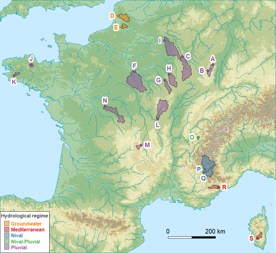
List of available catchments:
station_code | id_map | station_name |
A273011002 | A | the Bruche at Russ [Wisches] |
A605102001 | B | the Meurthe at Saint-Dié-des-Vosges |
B222001001 | C | the Meuse at Saint-Mihiel |
E540031001 | D | the Canche at Brimeux |
E645651001 | E | the Nièvre at Étoile |
F439000101 | F | the Loing at Épisy |
H010002001 | G | the Seine at Plaines-Saint-Lange |
H120101001 | H | the Aube at Bar-sur-Aube |
H622101001 | I | the Aisne at Givry |
J171171001 | J | the Trieux at Saint-Péver - Pont Locminé |
J421191001 | K | the Odet at Ergué-Gabéric - Treodet |
K134181001 | L | the Arroux at Rigny-sur-Arroux |
K265401001 | M | the Couze Pavin at Saint-Floret |
K731261001 | N | the Indre at Saint-Cyran-du-Jambot |
V123521001 | O | the Ire at Doussard |
X031001001 | P | the Durance at Embrun [La Clapière] - DREAL PACA |
X045401001 | Q | the Ubaye at Lauzet-Ubaye [Roche-Rousse] - DREAL PACA |
Y643401001 | R | the Esteron at Broc [La Clave] |
Y862000101 | S | the Taravo at Zigliara [Pont d'Abra] |
Source
Delaigue, O., Brigode, P., Andréassian, V., Perrin, C., Etchevers, P., Soubeyroux, J.M., Janet, B. and Addor, N. (2022). CAMELS-FR: A large sample hydroclimatic dataset for france to explore hydrological diversity and support model benchmarking. 11th edition of the IAHS Scientific Assembly. International Association of Hydrological Sciences, Montpellier, 29 May - 3 Jun. 2022. hal-03687235
References
Oudin, L., Hervieu, F., Michel, C., Perrin, C., Andréassian, V., Anctil, F. and Loumagne, C. (2005).
Which potential evapotranspiration input for a lumped rainfall-runoff model? Part 2 - Towards a simple and efficient potential evapotranspiration model for rainfall-runoff modelling.
Journal of Hydrology, 303(1-4), 290-306, doi:10.1016/j.jhydrol.2004.08.026.
SCHAPI (2022).
Hydroportail website. Retrieve hydrometric data from the French National Surface Water Quantity Database.
https://www.hydro.eaufrance.fr/.
Vidal, J.-P., Martin, E., Franchistéguy, L., Baillon, M. and Soubeyroux, J. (2010).
A 50-year high-resolution atmospheric reanalysis over France with the Safran system.
International Journal of Climatology, 30, 1627–1644, doi:10.1002/joc.2003.
Jarvis A., Reuter H.I., Nelson A. & Guevara E. (2008).
Hole-filled SRTM for the globe V4.
International Centre for Tropical Agriculture (CIAT).
Examples
library(airGRdatasets)

# list the datasets in the 'airGRdatasets' package
list_ds <- try(data(package = "airGRdatasets"), silent = TRUE)
list_ds$results[, "Item"]

# load the 'A273011002' catchment data
data(A273011002)

# display the structure of the data
str(A273011002)